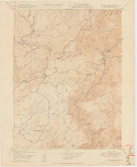
1949 Map of Brush Creek
USGS Topo · Published 1949About this map
Plumas National Forest and the rugged canyonlands of the Feather River define this late 1940s landscape on the Butte and Plumas county line. The settlement at Brush Creek serves as a central point for the surrounding highlands, while historic stopovers like Mountain House and Junction House hint at the earlier stage routes through these mountains. The terrain is deeply incised by the Middle Fork and Little North Fork, creating isolated bars such as Milsap Bar and American Bar that were once hubs of activity. Family life and early industry are marked by numerous named ranch sites, including Hinton Ranch and the Andy Smith Ranch, alongside the Horseshoe Mine near the northern boundary. The presence of a Ranger Station and several forest roads like Milsap Road show the area's mid-century management for timber and recreation.
Find a feature on this map
54 named features on this map. Tap any name to fly to it.
Don’t see what you’re looking for? This feature index may not catch every label — zoom into the map to look around manually.
Map Details
Editions of this 1949 Brush Creek Map
2 editions found
Other maps of this area

1888 · Bidwell Bar
USGS Topo · 1:125,000

1891 · Bidwell Bar
USGS Topo · 1:125,000

1893 · Bidwell Bar
USGS Topo · 1:125,000

1895 · Bidwell Bar
USGS Topo · 1:125,000

1897 · Bidwell Bar
USGS Topo · 1:125,000
1947 · Bidwell Bar
USGS Topo · 1:24,000
1947 · Brush Creek
USGS Topo · 1:24,000

1948 · Big Bend Mtn
USGS Topo · 1:62,500
1948 · Mooreville Ridge
USGS Topo · 1:62,500
1948 · Las Plumas
USGS Topo · 1:24,000