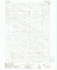
1985 Map of Brush Creek
USGS Topo · Published 1985About this map
Leach Lake and the complex drainage systems of the Nebraska Sandhills dominate this mid-1980s topographic survey. The landscape is defined by the winding paths of Brush Creek, Cedar Creek, and the dual branches of North Fork Plum Creek and South Fork Plum Creek. A notable man-made addition to the natural hydrology is the Ainsworth Private Canal, which cuts across the undulating terrain in the northern half of the quadrangle. Stretching along the boundary of Cherry Co and Brown Co, the map reveals a sparsely settled region primarily focused on water management and resource extraction, as evidenced by a Gravel Pit and numerous small water bodies like Dry Creek and Evergreen Creek. This document serves as a clear record of the intersection between natural waterways and private irrigation infrastructure in the high plains.
Find a feature on this map
10 named features on this map. Tap any name to fly to it.
Don’t see what you’re looking for? This feature index may not catch every label — zoom into the map to look around manually.
Map Details
Editions of this 1985 Brush Creek Map
This is the sole edition of this map. No revisions or reprints were ever made.
Other maps of this area

1949 · Long Lake
USGS Topo · 1:62,500

1950 · Wood Lake
USGS Topo · 1:62,500

1950 · Arabia
USGS Topo · 1:62,500

1951 · Long Lake
USGS Topo · 1:62,500

1951 · Moon Lake
USGS Topo · 1:62,500

1957 · Valentine
USGS Topo · 1:250,000

1959 · Valentine
USGS Topo · 1:250,000

1985 · Wilson Valley
USGS Topo · 1:24,000
1985 · Arabia SE
USGS Topo · 1:24,000
1985 · Wood Lake
USGS Topo · 1:24,000