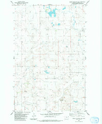
1983 Map of Brush Mountain SW
USGS Topo · Published 1984About this map
Clay Butte and Snake Butte dominate the landscape in this portion of Roosevelt County, where the high plains terrain is defined by drainage patterns and isolated water sources. The map captures the area in the early 1980s, revealing a sparsely populated region primarily characterized by its geography and small-scale land use. Sand Creek and Shotgun Creek carve through the north and west, while the presence of scattered wells and a Gravel Pit indicate the essential infrastructure required for life and industry in this open country. The southern section includes Nelson, a local topographic landmark, and the surveyed boundary line between Township 30 North and Township 29 North, reflecting the precise legal division of these Montana lands.
Find a feature on this map
8 named features on this map. Tap any name to fly to it.
Don’t see what you’re looking for? This feature index may not catch every label — zoom into the map to look around manually.
Map Details
Editions of this 1983 Brush Mountain SW Map
This is the sole edition of this map. No revisions or reprints were ever made.
Other maps of this area

1947 · Capeneys Lake
USGS Topo · 1:24,000

1948 · Capeneys Lake
USGS Topo · 1:24,000

1948 · Sunnyhill School
USGS Topo · 1:24,000

1949 · Sunnyhill School
USGS Topo · 1:24,000

1954 · Wolf Point
USGS Topo · 1:250,000

1958 · Wolf Point
USGS Topo · 1:250,000

1974 · Brush Mountain
USGS Topo · 1:24,000

1974 · Red Bank Creek
USGS Topo · 1:24,000
1974 · Bull Butte
USGS Topo · 1:24,000

1982 · Culbertson
USGS Topo · 1:100,000