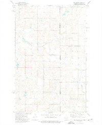
1974 Map of Bull Butte
USGS Topo · Published 1977About this map
Bull Butte rises as a prominent landmark above the section lines and coulees of the high plains along the Montana-North Dakota border. This mid-1970s survey captures the intersection of Roosevelt and Williams counties, where the landscape is defined by rural townships and the natural drainage of Little Muddy Creek and Sand Creek. The map provides specific detail for local researchers, noting the location of the Seventh-day Adventist Ch and industrial markers like a Gravel Pit and isolated Well. The township boundaries of Strandahl, Bull Butte, and Hebron reflect the traditional agricultural partitioning of this borderland region before modern shifts in land use.
Find a feature on this map
11 named features on this map. Tap any name to fly to it.
Don’t see what you’re looking for? This feature index may not catch every label — zoom into the map to look around manually.
Map Details
Editions of this 1974 Bull Butte Map
2 editions found
Other maps of this area

1948 · Sunnyhill School
USGS Topo · 1:24,000

1949 · Sunnyhill School
USGS Topo · 1:24,000

1953 · Williston
USGS Topo · 1:250,000

1954 · Wolf Point
USGS Topo · 1:250,000

1957 · Williston
USGS Topo · 1:250,000

1958 · Wolf Point
USGS Topo · 1:250,000

1974 · Brush Mountain
USGS Topo · 1:24,000

1974 · West Bonetraill
USGS Topo · 1:24,000

1974 · Red Bank Creek
USGS Topo · 1:24,000

1974 · Bonetraill SW
USGS Topo · 1:24,000