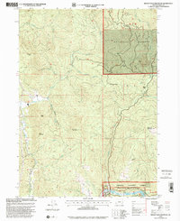
1998 Map of Brushy Bald Mountain
USGS Topo · Published 2001About this map
The Rogue National Wild And Scenic River defines the southern boundary of this coastal Oregon mountain survey, featuring a series of named rapids including Snow Riffle, Jennings Riffle, and William Miller Riffle. The landscape is dominated by the Siskiyou National Forest, where high elevations like Brushy Bald Mountain and First Prairie Mountain rise above a dense network of drainages such as Euchre Creek and Lobster Creek. Settlement is sparse, limited to the Colebrooke locality and the Sherman Ranch near Deadline Creek. The presence of the Boat Ramp Lobster Creek Rec Site and a Golf Course near Cedar Creek highlights the late 20th-century transition toward recreation and land management in these timberlands, while several Quarry sites and a Gravel Pit near Coffee Butte indicate ongoing resource extraction.
Find a feature on this map
39 named features on this map. Tap any name to fly to it.
Don’t see what you’re looking for? This feature index may not catch every label — zoom into the map to look around manually.
Map Details
Editions of this 1998 Brushy Bald Mountain Map
This is the sole edition of this map. No revisions or reprints were ever made.
Other maps of this area

1899 · Port Orford
USGS Topo · 1:125,000

1903 · Port Orford
USGS Topo · 1:125,000

1954 · Coos Bay
USGS Topo · 1:250,000

1954 · Port Orford
USGS Topo · 1:62,500

1954 · Gold Beach
USGS Topo · 1:62,500

1954 · Collier Butte
USGS Topo · 1:62,500

1954 · Agness
USGS Topo · 1:62,500

1958 · Coos Bay
USGS Topo · 1:250,000

1962 · Coos Bay
USGS Topo · 1:250,000
1986 · Father Mountain
USGS Topo · 1:24,000