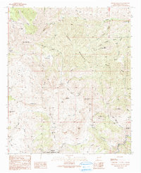
1990 Map of Brushy Mountain
USGS Topo · Published 1991About this map
Brushy Mountain dominates the center of this terrain, where the high ridges of the Gila National Forest drop toward the southwestern canyons of New Mexico. The landscape is defined by the drainage systems of Ash Creek and the Middle Gila River, revealing a history of seasonal range use and small-scale prospecting. Local history researchers will find evidence of ranching operations and water management through labels like the Walking H Windmill and Crows Nest Windmill, alongside remote outpost locations such as Ash Creek Camp and Slate Creek Camp.
Find a feature on this map
60 named features on this map. Tap any name to fly to it.
Don’t see what you’re looking for? This feature index may not catch every label — zoom into the map to look around manually.
Map Details
Editions of this 1990 Brushy Mountain Map
This is the sole edition of this map. No revisions or reprints were ever made.
Other maps of this area

1954 · Silver City
USGS Topo · 1:250,000

1958 · Silver City
USGS Topo · 1:250,000

1959 · Steeple Rock
USGS Topo · 1:62,500

1959 · Redrock
USGS Topo · 1:62,500

1959 · Canador Peak
USGS Topo · 1:62,500

1959 · Cliff
USGS Topo · 1:62,500

1962 · Silver City
USGS Topo · 1:250,000
1990 · Cliff
USGS Topo · 1:24,000
1990 · Bullard Peak
USGS Topo · 1:24,000
1990 · Antelope Ridge
USGS Topo · 1:24,000