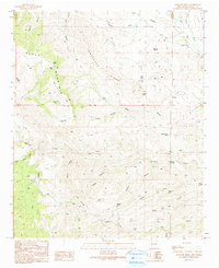
1990 Map of Antelope Ridge
USGS Topo · Published 1991About this map
Antelope Ridge and the prominent Black Mountain dominate this corner of Grant County, where the high desert landscape is defined by a series of dramatic canyons and drainage systems. This 1990 provisional update reveals a territory shaped by ranching and resource exploration, marked by numerous prospect sites and an extensive network of 4WD trails. The distribution of water is critical here, evidenced by named features like Horse Lake, Sycamore Creek, and Duck Creek, alongside specialized ranching infrastructure such as the Willmeth Windmill.
Find a feature on this map
46 named features on this map. Tap any name to fly to it.
Don’t see what you’re looking for? This feature index may not catch every label — zoom into the map to look around manually.
Map Details
Editions of this 1990 Antelope Ridge Map
This is the sole edition of this map. No revisions or reprints were ever made.
Other maps of this area

1910 · Mogollon
USGS Topo · 1:125,000

1912 · Mogollon
USGS Topo · 1:125,000

1954 · Silver City
USGS Topo · 1:250,000

1954 · Clifton
USGS Topo · 1:250,000

1957 · Clifton
USGS Topo · 1:250,000

1958 · Silver City
USGS Topo · 1:250,000

1958 · Clifton
USGS Topo · 1:250,000

1959 · Steeple Rock
USGS Topo · 1:62,500

1959 · Cliff
USGS Topo · 1:62,500

1962 · Silver City
USGS Topo · 1:250,000