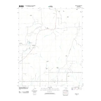
2010 Map of Brushy
USGS Topo · Published 2010About this map
The Brushy Mountains dominate the northern landscape of this Oklahoma quadrangle, where high ridges like Long Ridge and Hay Ridge overlook a complex network of creeks and bayous. In the early 21st century, the area displays a rural pattern of development focused on water management and ranching, evidenced by numerous flood control structures such as Sallisaw Creek Site 30 Dam and Sallisaw Creek Site 37 Dam. Local history is anchored by several burial sites, including Brushy Cemetery, Sequoyah Cemetery, and Akins Cemetery, which provide vital touchstones for genealogical research in Sequoyah County.
Find a feature on this map
41 named features on this map. Tap any name to fly to it.
Don’t see what you’re looking for? This feature index may not catch every label — zoom into the map to look around manually.
Map Details
Editions of this 2010 Brushy Map
This is the sole edition of this map. No revisions or reprints were ever made.
Other maps of this area

1898 · Tahlequah
USGS Topo · 1:125,000

1900 · Sallisaw
USGS Topo · 1:125,000

1901 · Tahlequah
USGS Topo · 1:125,000

1905 · Tahlequah
USGS Topo · 1:125,000

1911 · Sallisaw
USGS Topo · 1:125,000

1946 · Fort Smith
USGS Topo · 1:250,000

1965 · Fort Smith
USGS Topo · 1:250,000
1966 · Muldrow
USGS Topo · 1:24,000

1966 · Gans
USGS Topo · 1:24,000

1967 · Fort Smith
USGS Topo · 1:250,000