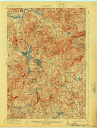
1914 Map of Bryant Pond
USGS Topo · Published 1924About this map
Bryant Pond sits at the heart of this Oxford County landscape, where the Grand Trunk railroad follows the winding valleys to connect the mill towns of the early twentieth century. The map reveals a mountain-and-water economy defined by industrial sites like Abbott's Mill and Walker's Mill, alongside numerous rural community hubs including the Tubby School, Martin School, and Patch Mountain School. This era predates the widespread automation of the logging and milling industries, showing the dense network of local roads and family-named landmarks that once supported a thriving upland population.
Find a feature on this map
138 named features on this map. Tap any name to fly to it.
Don’t see what you’re looking for? This feature index may not catch every label — zoom into the map to look around manually.
Map Details
Editions of this 1914 Bryant Pond Map
4 editions found
Other maps of this area

1896 · Norway
USGS Topo · 1:62,500

1908 · Poland
USGS Topo · 1:62,500

1909 · Fryeburg
USGS Topo · 1:62,500

1911 · Fryeburg
USGS Topo · 1:62,500

1911 · Bryant Pond
USGS Topo · 1:62,500

1911 · Buckfield
USGS Topo · 1:62,500

1913 · Buckfield
USGS Topo · 1:62,500

1914 · Bethel
USGS Topo · 1:62,500

1914 · Bryant Pond
USGS Topo · 1:62,500

1926 · Dixfield
USGS Topo · 1:62,500