1976 Map of Bryson City
USGS Topo · Published 1978About this map
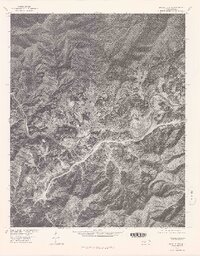
Bryson City serves as the focal point of this 1976 orthophotograph, where the winding course of the Tuckasegee River meets the eastern reaches of Fontana Lake. This aerial survey, produced in cooperation with the Bureau of Indian Affairs, reveals the town's layout and the tight valley topography of the surrounding Quark Mountains. The imagery clearly shows the road networks connecting the main settlement to smaller areas like Ela and identifies the prominent Lackey Hill overlooking the river valley. For those researching land divisions, the Jackson Line boundary is noted, providing a specific reference point for local history and property research within Swain County during the mid-1970s.
Find a feature on this map
8 named features on this map. Tap any name to fly to it.
Don’t see what you’re looking for? This feature index may not catch every label — zoom into the map to look around manually.
Map Details
Editions of this 1976 Bryson City Map
This is the sole edition of this map. No revisions or reprints were ever made.
Other maps of this area

1886 · Knoxville
USGS Topo · 1:125,000

1891 · Cowee
USGS Topo · 1:125,000

1892 · Knoxville
USGS Topo · 1:125,000

1893 · Mt Guyot
USGS Topo · 1:125,000

1894 · Knoxville
USGS Topo · 1:125,000

1895 · Knoxville
USGS Topo · 1:125,000

1897 · Cowee
USGS Topo · 1:125,000

1901 · Knoxville
USGS Topo · 1:125,000

1907 · Cowee
USGS Topo · 1:125,000

1912 · Mt Guyot
USGS Topo · 1:125,000