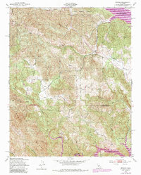
1949 Map of Bryson
USGS Topo · Published 1985About this map
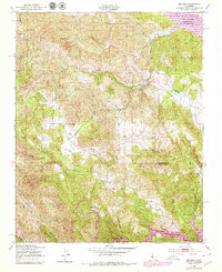
The Sapaque Valley provides a clear view of mid-century rural Monterey County, where the settlement of Bryson sits at the junction of the Sapaque Creek and several mountain drainages. This landscape is defined by the sharp transition between military and recreational land use, with the northern portion occupied by Fort Hunter Liggett. The introduction of major water infrastructure is evident in the presence of the San Antonio Reservoir Recreation Area and Lake San Antonio, which drastically altered the local topography. Local educational history is preserved through the locations of the Hesperia Sch and Pleyto Sch, while family-run operations like Smith Ranch and various Windmill sites suggest a resilient ranching economy. The map also traces the Nacimiento River as it winds through the Santa Lucia Range, crossing the border between Monterey and San Luis Obispo counties at Beasley Flat.
Find a feature on this map
31 named features on this map. Tap any name to fly to it.
Don’t see what you’re looking for? This feature index may not catch every label — zoom into the map to look around manually.
Map Details
Editions of this 1949 Bryson Map
6 editions found
Other maps of this area

1919 · Bryson
USGS Topo · 1:62,500

1919 · Bradley
USGS Topo · 1:62,500

1919 · Adelaida
USGS Topo · 1:62,500

1919 · San Simeon
USGS Topo · 1:62,500

1932 · Adelaida
USGS Topo · 1:62,500

1937 · San Simeon
USGS Topo · 1:62,500

1941 · Bradley
USGS Topo · 1:62,500

1941 · Bryson
USGS Topo · 1:62,500

1942 · Adelaida
USGS Topo · 1:62,500

1942 · Bryson
USGS Topo · 1:62,500