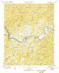
1940 Map of Bryson
USGS Topo · Published 1957About this map
Bryson City sits at the heart of this 1940 survey, positioned where the Tuckasegee River meets the expanding waters of Fontana Lake. The landscape is a complex meeting of jurisdictions, showing the boundary between the Great Smoky Mountains National Park to the north and the Nantahala National Forest to the south. The Southern Railway follows the river's winding course, connecting settlements like Ela and Governors Island to the regional economy.
Find a feature on this map
114 named features on this map. Tap any name to fly to it.
Don’t see what you’re looking for? This feature index may not catch every label — zoom into the map to look around manually.
Map Details
Editions of this 1940 Bryson Map
This is the sole edition of this map. No revisions or reprints were ever made.
Other maps of this area

1886 · Knoxville
USGS Topo · 1:125,000

1891 · Cowee
USGS Topo · 1:125,000

1892 · Knoxville
USGS Topo · 1:125,000

1893 · Mt Guyot
USGS Topo · 1:125,000

1894 · Knoxville
USGS Topo · 1:125,000

1895 · Knoxville
USGS Topo · 1:125,000

1897 · Cowee
USGS Topo · 1:125,000

1901 · Knoxville
USGS Topo · 1:125,000

1907 · Cowee
USGS Topo · 1:125,000

1912 · Mt Guyot
USGS Topo · 1:125,000