
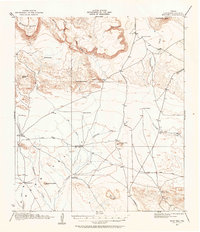
1917 Map of Buck Hill
USGS Topo · Published 1957About this map
Mitchell Mesa and Elephant Mtn dominate the high-desert horizon in this 1917 survey of Brewster County. The landscape is defined by the vital, if intermittent, drainage networks of Calamity Creek and Terlingua Creek, which provided the essential water needed for the region's ranching economy. The map documents a sparse but established network of cattle operations, from the Kokernot Ranch in the north to Wilsons Ranch and the O 2 Ranch in the west. Human presence is further evidenced by isolated structures like Plank House and essential water infrastructure such as Brush Windmill and Cobas Windmill. This survey also records a moment of local transition, labeling the Loy Place (Abandoned) while identifying other active residences like Sid Place. These details offer a precise look at West Texas survival and land use before mid-century modernizations reached this corner of the Big Bend country.
Find a feature on this map
35 named features on this map. Tap any name to fly to it.
Don’t see what you’re looking for? This feature index may not catch every label — zoom into the map to look around manually.
Map Details
Editions of this 1917 Buck Hill Map
2 editions found
Other maps of this area

1895 · Alpine
USGS Topo · 1:125,000

1917 · Agua Fria
USGS Topo · 1:62,500

1917 · Tascotal Mesa
USGS Topo · 1:62,500

1917 · Santiago Peak
USGS Topo · 1:62,500

1918 · Bone Spring
USGS Topo · 1:125,000

1918 · Buck Hill
USGS Topo · 1:62,500

1918 · Santiago Peak
USGS Topo · 1:62,500

1918 · Jordan Gap
USGS Topo · 1:62,500

1918 · Nine Point Mesa
USGS Topo · 1:62,500

1920 · Monument Spring
USGS Topo · 1:62,500