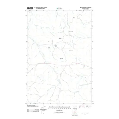
2011 Map of Buck Mountain
USGS Topo · Published 2011About this map
Buck Mountain stands as a central topographic point in this high plains landscape of Custer County, Montana. The drainage patterns here are complex and well-defined, with numerous seasonal and perennial waterways like Little Cottonwood Creek and Wolf Creek carving through the terrain. Evidence of ranching and land management appears in the form of the Ogdahl Number 3 Dam, a small-scale water control feature that highlights the importance of resource management in this arid region. The area is characterized by distinct peaks and ridges, including Sunrise Peak, Baldy Peak, and the Blue Mountains, which provide a sense of the local relief. Various smaller tributaries such as Cedar Canyon Creek and Trough Creek feed into the larger creek systems, while isolated water sources like Log Spring suggest the traditional locations of crucial water points for early travelers and livestock in the open range.
Find a feature on this map
25 named features on this map. Tap any name to fly to it.
Don’t see what you’re looking for? This feature index may not catch every label — zoom into the map to look around manually.
Map Details
Editions of this 2011 Buck Mountain Map
This is the sole edition of this map. No revisions or reprints were ever made.
Other maps of this area

1953 · Miles City
USGS Topo · 1:250,000

1957 · Miles City
USGS Topo · 1:250,000

1958 · Miles City
USGS Topo · 1:250,000

1969 · Corral Butte
USGS Topo · 1:24,000

1969 · Haines Springs
USGS Topo · 1:24,000

1969 · Spring Draw
USGS Topo · 1:24,000

1969 · Locate SE
USGS Topo · 1:24,000

1969 · The Knob
USGS Topo · 1:24,000

1969 · Buck Mountain
USGS Topo · 1:24,000
1969 · Shirley
USGS Topo · 1:24,000