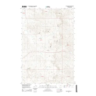
2014 Map of Buck Mountain
USGS Topo · Published 2014About this map
The Pine Hills rise across the southern landscape of this Custer County interior, where high ridges and deep drainages define the Montana terrain. This 2014 survey captures a network of summits including Buck Mtn, Baldy Peak, and Sunrise Peak, which anchor a complex system of seasonal watercourses. The central corridor is dominated by Cedar Canyon, with Cedar Canyon Cr and Little Cottonwood Cr carving paths through the breaks. Us-12 provides the primary east-west passage across the quadrangle, cutting between the larger Blue Mountains and the northern slopes of the Pine Hills. Notable local landmarks like Log Spring and the high point of Green Mtn offer reference points for those navigating the open range and remote creek valleys of the Yellowstone River watershed.
Find a feature on this map
29 named features on this map. Tap any name to fly to it.
Don’t see what you’re looking for? This feature index may not catch every label — zoom into the map to look around manually.
Map Details
Editions of this 2014 Buck Mountain Map
This is the sole edition of this map. No revisions or reprints were ever made.
Other maps of this area

1953 · Miles City
USGS Topo · 1:250,000

1957 · Miles City
USGS Topo · 1:250,000

1958 · Miles City
USGS Topo · 1:250,000

1969 · Corral Butte
USGS Topo · 1:24,000

1969 · Haines Springs
USGS Topo · 1:24,000

1969 · Spring Draw
USGS Topo · 1:24,000

1969 · Locate SE
USGS Topo · 1:24,000

1969 · The Knob
USGS Topo · 1:24,000

1969 · Buck Mountain
USGS Topo · 1:24,000
1969 · Shirley
USGS Topo · 1:24,000