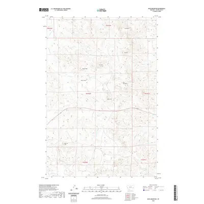
2020 Map of Buck Mountain
USGS Topo · Published 2020About this map
Buck Mtn and Baldy Peak command the high ground of this Custer County landscape, where the broken terrain of the Blue Mountains and The Pine Hills meets a dense network of seasonal drainages. The topography is defined by sharp elevation changes between summits like Sunrise Peak and the deep incisions of Cedar Canyon. This 2020 edition provides a clear view of the water sources critical to this arid region, such as Log Spring and the headwaters of Schlosser Cr, Trough Cr, and Little Cottonwood Cr. The map reveals a land divided by township and range lines, primarily used for ranching and resource management, with Route 12 serving as the primary corridor through the southern reaches. Local history researchers can trace the intricate pathways of Smith Cr and its tributaries, including N Fork Smith Cr and Fortyfour Cr, as they wind through the eastern hills.
Find a feature on this map
31 named features on this map. Tap any name to fly to it.
Don’t see what you’re looking for? This feature index may not catch every label — zoom into the map to look around manually.
Map Details
Editions of this 2020 Buck Mountain Map
This is the sole edition of this map. No revisions or reprints were ever made.
Other maps of this area

1953 · Miles City
USGS Topo · 1:250,000

1957 · Miles City
USGS Topo · 1:250,000

1958 · Miles City
USGS Topo · 1:250,000

1969 · Corral Butte
USGS Topo · 1:24,000

1969 · Haines Springs
USGS Topo · 1:24,000

1969 · Spring Draw
USGS Topo · 1:24,000

1969 · Locate SE
USGS Topo · 1:24,000

1969 · The Knob
USGS Topo · 1:24,000

1969 · Buck Mountain
USGS Topo · 1:24,000
1969 · Shirley
USGS Topo · 1:24,000