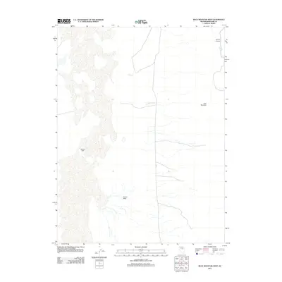
2012 Map of Buck Mountain West
USGS Topo · Published 2012About this map
Newark Lake sits at the western edge of this Nevada landscape, dominating the floor of the Newark Valley. The terrain rises sharply to the east, defined by the slopes of Buck Mountain and the drainage of Orchard Canyon. This 2012 survey illustrates the arid hydrography of White Pine County, where seasonal or ephemeral water features like Deadman Creek and Moore Springs dictate the character of the high desert. The transportation network is minimal, represented by the path of Co Rd 1 as it skirts the mountain foothills. The map provides a clear look at the geological transitions between the valley floor and the surrounding peaks, capturing the isolation and environmental specifics of the Great Basin region.
Find a feature on this map
7 named features on this map. Tap any name to fly to it.
Don’t see what you’re looking for? This feature index may not catch every label — zoom into the map to look around manually.
Map Details
Editions of this 2012 Buck Mountain West Map
This is the sole edition of this map. No revisions or reprints were ever made.
Other maps of this area

1953 · Eureka
USGS Topo · 1:62,500

1956 · Ely
USGS Topo · 1:250,000

1957 · Buck Mountain
USGS Topo · 1:62,500

1957 · Diamond Springs
USGS Topo · 1:62,500

1957 · Cold Creek Ranch
USGS Topo · 1:62,500

1959 · Ely
USGS Topo · 1:250,000

1963 · Ely
USGS Topo · 1:250,000

1985 · Newark Lake
USGS Topo · 1:100,000
1990 · Buck Mountain East
USGS Topo · 1:24,000
1990 · Diamond Peak
USGS Topo · 1:24,000