
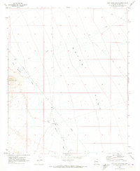
1970 Map of Buck Mountains NE
USGS Topo · Published 1982About this map
Dutch Flat dominates the eastern half of this Mohave County landscape, where the wide, arid expanse meets the rising slopes of the Buck Mountains to the west. Surveyed in 1970, the map illustrates a remote part of Arizona defined by seasonal drainage and ranching infrastructure. A primary landmark of interest is the uniquely named Shot Up Well, situated at the intersection of mountain runoff and the flatlands. Drainage patterns such as Cow Creek and Buck Mountain Wash carve through the terrain, indicating the flow of water during infrequent desert rains. Human presence in the region is marked by utility and transport networks, including a long Pipeline segment, the Dutch Flat Road, and various Jeep Trails that provided essential access for land management and early modern exploration in this sparsely populated desert basin.
Find a feature on this map
8 named features on this map. Tap any name to fly to it.
Don’t see what you’re looking for? This feature index may not catch every label — zoom into the map to look around manually.
Map Details
Editions of this 1970 Buck Mountains NE Map
2 editions found
Other maps of this area

1923 · Signal
USGS Topo · 1:250,000
1927 · Yucca
USGS Topo · 1:62,500

1927 · Buck Mountains
USGS Topo · 1:62,500

1929 · Buck Mountains
USGS Topo · 1:62,500
1929 · Yucca
USGS Topo · 1:62,500

1942 · Signal
USGS Topo · 1:250,000

1950 · Prescott
USGS Topo · 1:250,000

1954 · Needles
USGS Topo · 1:250,000

1954 · Prescott
USGS Topo · 1:250,000

1956 · Needles
USGS Topo · 1:250,000