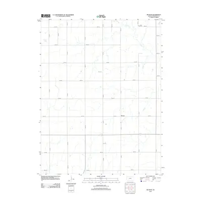
2012 Map of Buckeye
USGS Topo · Published 2012About this map
Buckeye anchors this section of Dickinson County, where the landscape is defined by a strictly surveyed grid of agricultural access roads and the wandering course of Chapman Cr in the northeast. The rural character of the area is underscored by the presence of three distinct burial grounds serving the local farming community: Green Ridge Cem, Henry Cem, and Union Cem. This 2012 survey illustrates the enduring township-and-range layout typical of the Kansas plains, with named thoroughfares like Flag Rd and Jeep Rd cutting through the open country. The placement of the cemeteries away from the primary settlement at Buckeye suggests an older pattern of family or neighborhood-centered interments that have persisted even as modern infrastructure like 3300 Ave and Key Rd connects the region.
Find a feature on this map
25 named features on this map. Tap any name to fly to it.
Don’t see what you’re looking for? This feature index may not catch every label — zoom into the map to look around manually.
Map Details
Editions of this 2012 Buckeye Map
This is the sole edition of this map. No revisions or reprints were ever made.
Other maps of this area

1889 · Abilene
USGS Topo · 1:125,000

1891 · Clay Center
USGS Topo · 1:125,000

1894 · Abilene
USGS Topo · 1:125,000

1955 · Manhattan
USGS Topo · 1:250,000

1955 · Hutchinson
USGS Topo · 1:250,000

1956 · Manhattan
USGS Topo · 1:250,000

1957 · Manhattan
USGS Topo · 1:250,000

1959 · Hutchinson
USGS Topo · 1:250,000
1963 · Upland
USGS Topo · 1:24,000
1963 · Solomon
USGS Topo · 1:24,000