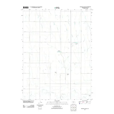
2011 Map of Buckeye Valley
USGS Topo · Published 2011About this map
Wood River winds across the southern reaches of this Buffalo County landscape, providing the primary drainage for the surrounding agricultural terrain. The map captures a section of Nebraska defined by a systematic grid of section-line roads, including the aptly named Pole Line Rd and Poole Rd, which organize the homesteads and farms of Buckeye Valley. Several water management features are prominent, such as Randall Reservoir and Rogers Reservoir, held by their respective landmarks, Randall Dam and Rogers Dam. These reservoirs, along with Cedar Creek and Sweet Creek, highlight the essential role of water control in this plains environment. In the southeast corner near the river, Riverside Cemetery stands as a significant point for genealogical research, anchoring the local history of the families that settled this valley.
Find a feature on this map
29 named features on this map. Tap any name to fly to it.
Don’t see what you’re looking for? This feature index may not catch every label — zoom into the map to look around manually.
Map Details
Editions of this 2011 Buckeye Valley Map
This is the sole edition of this map. No revisions or reprints were ever made.
Other maps of this area

1894 · Kearney
USGS Topo · 1:62,500

1894 · Minden
USGS Topo · 1:62,500

1896 · Kearney
USGS Topo · 1:125,000

1896 · Wood River
USGS Topo · 1:125,000

1955 · Grand Island
USGS Topo · 1:250,000

1957 · Grand Island
USGS Topo · 1:250,000

1958 · Grand Island
USGS Topo · 1:250,000

1962 · Newark
USGS Topo · 1:24,000
1962 · Poole NE
USGS Topo · 1:24,000
1962 · Pleasanton SE
USGS Topo · 1:24,000