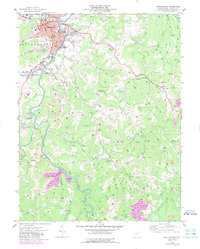
1974 Map of Buckhannon
USGS Topo · Published 1989About this map
The Buckhannon River serves as the primary artery for this portion of Upshur County, winding through a landscape of tight valleys and industrial extraction. In the north, the city of Buckhannon is the clear center of activity, home to West Virginia Wesleyan College, St Josephs Hospital, and various civic landmarks like the Courthouse and City Hall. The Baltimore and Ohio railroad corridor traces the river, supporting the region’s economic life alongside numerous strip mines that mark the surrounding hills. Beyond the city limits, smaller settlements like Tallmansville, Hampton, and Sago are linked by a network of runs and creeks, including Jawbone Run and French Creek. Cultural life is evident in the many rural landmarks, from the Drive-In Theater near Tennerton to the Bailey Ridge Community Center and historical sites like Mt Herman Cem.
Find a feature on this map
76 named features on this map. Tap any name to fly to it.
Don’t see what you’re looking for? This feature index may not catch every label — zoom into the map to look around manually.
Map Details
Editions of this 1974 Buckhannon Map
This is the sole edition of this map. No revisions or reprints were ever made.
Other maps of this area

1893 · Buckhannon
USGS Topo · 1:125,000

1896 · Buckhannon
USGS Topo · 1:125,000

1897 · Buckhannon
USGS Topo · 1:125,000

1904 · Philippi
USGS Topo · 1:62,500

1904 · Weston
USGS Topo · 1:62,500

1912 · Sago
USGS Topo · 1:48,000

1912 · Crawford
USGS Topo · 1:48,000

1914 · Sago
USGS Topo · 1:62,500

1914 · Crawford
USGS Topo · 1:62,500

1925 · Philippi
USGS Topo · 1:62,500