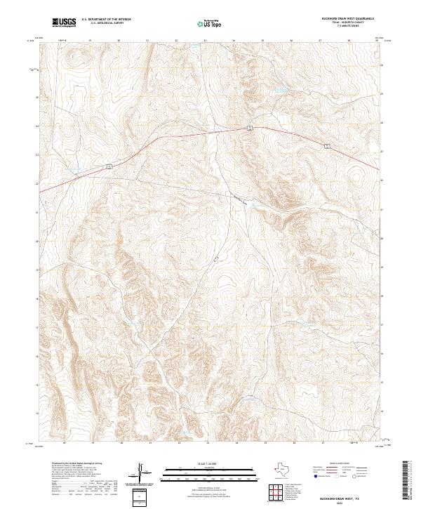
2022 Map of Buckhorn Draw West
USGS Topo · Published 2022About this map
Buck Horn Draw serves as the primary drainage through this arid landscape of Hudspeth County, winding through a complex network of topographical ridges. The map reveals an intensive system of water management essential for ranching or land use in this desert environment, marked by numerous named catchments. Notable water features include Panther Tanks and Fernando Tank in the north, while Colorado Tank and Pescado Tank define the southern reaches. The naming conventions, including Beard Number Two Tank and Tony Number One Tank, suggest a legacy of specific land ownership or historical ranching divisions. This terrain is characterized by its high-elevation contouring and the strategic placement of these artificial or improved water sources alongside the natural path of the draw.
Find a feature on this map
12 named features on this map. Tap any name to fly to it.
Don’t see what you’re looking for? This feature index may not catch every label — zoom into the map to look around manually.
Map Details
Editions of this 2022 Buckhorn Draw West Map
This is the sole edition of this map. No revisions or reprints were ever made.
Other maps of this area

1903 · Cerro Alto
USGS Topo · 1:125,000

1941 · Heuco Mountains
USGS Topo · 1:62,500

1942 · Borrego
USGS Topo · 1:62,500

1943 · Tepee Butte
USGS Topo · 1:62,500

1943 · San Antonio Mtn
USGS Topo · 1:62,500

1943 · Heuco Mountains
USGS Topo · 1:62,500

1954 · Van Horn
USGS Topo · 1:250,000

1958 · Van Horn
USGS Topo · 1:250,000
1978 · Wildhorse Draw
USGS Topo · 1:24,000
1978 · Padre Canyon
USGS Topo · 1:24,000