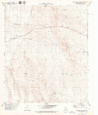
1979 Map of Buckhorn Draw West
USGS Topo · Published 1979About this map
Buckhorn Draw carves through this arid corner of West Texas, defining a landscape shaped by intermittent water and high-altitude ranching. This 1970s survey captures a sparse but critical network of water management features, including Panther Tanks, Tony Tank No 1, and Pescado Tank, which supported livestock in a region where surface water is a rare commodity. The map shows the infrastructure of the late twentieth century, with a large Pipeline cutting across the northern reaches and a Gravel Pit near the highway, indicating the local industrial activity and resource extraction of the era.
Find a feature on this map
16 named features on this map. Tap any name to fly to it.
Don’t see what you’re looking for? This feature index may not catch every label — zoom into the map to look around manually.
Map Details
Editions of this 1979 Buckhorn Draw West Map
This is the sole edition of this map. No revisions or reprints were ever made.
Other maps of this area

1903 · Cerro Alto
USGS Topo · 1:125,000

1941 · Heuco Mountains
USGS Topo · 1:62,500

1942 · Borrego
USGS Topo · 1:62,500

1943 · Tepee Butte
USGS Topo · 1:62,500

1943 · San Antonio Mtn
USGS Topo · 1:62,500

1943 · Heuco Mountains
USGS Topo · 1:62,500

1954 · Van Horn
USGS Topo · 1:250,000

1958 · Van Horn
USGS Topo · 1:250,000
1978 · Wildhorse Draw
USGS Topo · 1:24,000
1978 · Padre Canyon
USGS Topo · 1:24,000