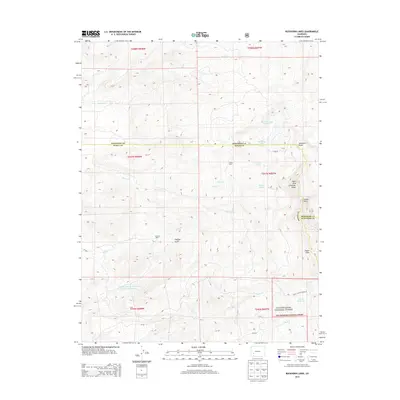
2013 Map of Buckhorn Lakes
USGS Topo · Published 2013About this map
Storm King Cimarron Ridge dominates the eastern horizon of this 2013 survey, where the high-altitude boundaries of Montrose, Ouray, and Gunnison counties converge. The landscape is defined by its complex drainage systems and isolated homestead markers, including the Jutten Cabin near the Onion Lakes and the Comerer Ranch situated along Chaffee Gulch. This map provides a look at the varied water management features of the area, from natural alpine basins like Buckhorn Lake Number 1 and Jutten Lakes to engineered structures such as the Chaffe Gulch Dentention Number 6 Reservoir and Coons Reservoir. Navigation through the Uncompahgre National Forest in the southeast is charted via the Deer Creek Trl 6223.0, passing landmarks like Sawtooth Rocks and the prominent Castle Rock.
Find a feature on this map
34 named features on this map. Tap any name to fly to it.
Don’t see what you’re looking for? This feature index may not catch every label — zoom into the map to look around manually.
Map Details
Editions of this 2013 Buckhorn Lakes Map
This is the sole edition of this map. No revisions or reprints were ever made.
Other maps of this area

1902 · Ouray
USGS Topo · 1:62,500

1904 · Ouray
USGS Topo · 1:62,500

1909 · Montrose
USGS Topo · 1:125,000

1911 · Montrose
USGS Topo · 1:125,000

1956 · Cimarron
USGS Topo · 1:24,000

1956 · Montrose
USGS Topo · 1:250,000

1957 · Cerro Summit
USGS Topo · 1:24,000

1959 · Montrose
USGS Topo · 1:250,000

1960 · Montrose
USGS Topo · 1:250,000
1962 · Montrose East
USGS Topo · 1:24,000