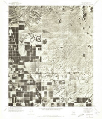
1971 Map of Buckhorn
USGS Topo · Published 1972About this map
Salt River flows across the northern edge of this orthophotomap, defining a sharp boundary between the dramatic desert geology and the expanding agricultural grid of the East Valley. The 1971 aerial perspective captures the complex hydraulic landscape necessary for life in the desert, tracing the Roosevelt Canal as it cuts diagonally through a mosaic of dark irrigated fields. Central to this transition is Buckhorn, where the organized rows of crops meet emerging residential developments. To the east, the terrain rises abruptly from the flat basin into the distinct volcanic profile of Spook Hill. This map provides a rare visual record of Maricopa County at a moment when traditional desert farming began to yield to the suburban sprawl that would eventually characterize the region.
Find a feature on this map
4 named features on this map. Tap any name to fly to it.
Don’t see what you’re looking for? This feature index may not catch every label — zoom into the map to look around manually.
Map Details
Editions of this 1971 Buckhorn Map
This is the sole edition of this map. No revisions or reprints were ever made.
Other maps of this area

1904 · Camelback
USGS Topo · 1:62,500

1904 · Desert Well
USGS Topo · 1:62,500

1904 · Ft. McDowell
USGS Topo · 1:62,500

1906 · Camelsback
USGS Topo · 1:62,500

1906 · Ft. McDowell
USGS Topo · 1:62,500

1906 · Desert Well
USGS Topo · 1:62,500

1913 · Mesa
USGS Topo · 1:62,500

1915 · Mesa
USGS Topo · 1:62,500

1930 · Cave Creek
USGS Topo · 1:125,000

1939 · Cave Creek
USGS Topo · 1:125,000