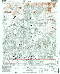
2004 Map of Buckhorn
USGS Topo · Published 2007About this map
The city of Mesa and the community of Buckhorn are shown here during a period of significant suburban expansion in the Salt River Valley. The map captures a complex network of water management, with the Salt River flowing along the northern edge and the Arizona Canal and Consolidated Canal cutting through the residential landscape. This infrastructure supported the region's transition from an agricultural hub to a major residential center.
Find a feature on this map
52 named features on this map. Tap any name to fly to it.
Don’t see what you’re looking for? This feature index may not catch every label — zoom into the map to look around manually.
Map Details
Editions of this 2004 Buckhorn Map
This is the sole edition of this map. No revisions or reprints were ever made.
Other maps of this area

1904 · Camelback
USGS Topo · 1:62,500

1904 · Desert Well
USGS Topo · 1:62,500

1904 · Ft. McDowell
USGS Topo · 1:62,500

1906 · Camelsback
USGS Topo · 1:62,500

1906 · Ft. McDowell
USGS Topo · 1:62,500

1906 · Desert Well
USGS Topo · 1:62,500

1913 · Mesa
USGS Topo · 1:62,500

1915 · Mesa
USGS Topo · 1:62,500

1930 · Cave Creek
USGS Topo · 1:125,000

1939 · Cave Creek
USGS Topo · 1:125,000