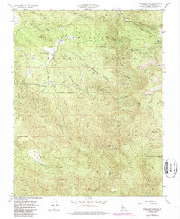
1947 Map of Buckhorn Peak
USGS Topo · Published 1987About this map
Stanislaus National Forest anchors this rugged Mariposa County landscape, where the 1940s mining and ranching legacies are clearly defined. The terrain is deeply incised by the North Fork Merced River and numerous drainages like Indian Gulch and Solomon Gulch, creating a complex network of ridges including Banderita Ridge. The map documents a significant era of resource extraction, noting the Bondurant Mine, Marble Spring Mine, and Red Cloud Mine, which reflect the region's enduring connection to California's Gold Country history.
Find a feature on this map
34 named features on this map. Tap any name to fly to it.
Don’t see what you’re looking for? This feature index may not catch every label — zoom into the map to look around manually.
Map Details
Editions of this 1947 Buckhorn Peak Map
4 editions found
Other maps of this area

1893 · Sonora
USGS Topo · 1:125,000

1896 · Sonora
USGS Topo · 1:125,000

1897 · Sonora
USGS Topo · 1:125,000

1897 · Yosemite
USGS Topo · 1:125,000

1898 · Sonora
USGS Topo · 1:125,000

1900 · Yosemite
USGS Topo · 1:125,000

1903 · Yosemite
USGS Topo · 1:125,000

1909 · Yosemite
USGS Topo · 1:125,000

1947 · San Jose
USGS Topo · 1:250,000

1947 · Mariposa
USGS Topo · 1:250,000