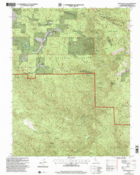
2001 Map of Buckhorn Peak
USGS Topo · Published 2004About this map
Red Cloud Mine and Bondurant Mine anchor the northern reaches of this Mariposa County landscape, marking a history of extraction within the Stanislaus National Forest. The rugged terrain is defined by the steep descent toward the North Fork Merced River, which cuts through the eastern portion of the quadrangle. Historic transportation routes, including the Coulterville Old Yosemite Road and the appropriately named Dogtown Road, suggest the movement of people and supplies between early settlements and mining claims.
Find a feature on this map
31 named features on this map. Tap any name to fly to it.
Don’t see what you’re looking for? This feature index may not catch every label — zoom into the map to look around manually.
Map Details
Editions of this 2001 Buckhorn Peak Map
2 editions found
Other maps of this area

1893 · Sonora
USGS Topo · 1:125,000

1896 · Sonora
USGS Topo · 1:125,000

1897 · Sonora
USGS Topo · 1:125,000

1897 · Yosemite
USGS Topo · 1:125,000

1898 · Sonora
USGS Topo · 1:125,000

1900 · Yosemite
USGS Topo · 1:125,000

1903 · Yosemite
USGS Topo · 1:125,000

1909 · Yosemite
USGS Topo · 1:125,000

1947 · San Jose
USGS Topo · 1:250,000

1947 · Mariposa
USGS Topo · 1:250,000