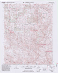
2001 Map of Buckhorn Peak
USGS Topo · Published 2004About this map
The historic Old Coulterville Yosemite Road traverses the northern section of this territory within the Stanislaus National Forest. This 2001 revision illustrates the varied terrain of the Mariposa backcountry, where mining activity is evidenced by the Red Cloud Mine and numerous prospects scattered near Jackass Mountain. The map details a complex network of forest routes, including Bondurant Road and Ponderosa Way, which wind through ridges and flats such as Date Flat and Coalpit Hill.
Find a feature on this map
33 named features on this map. Tap any name to fly to it.
Don’t see what you’re looking for? This feature index may not catch every label — zoom into the map to look around manually.
Map Details
Editions of this 2001 Buckhorn Peak Map
2 editions found
Other maps of this area

1893 · Sonora
USGS Topo · 1:125,000

1896 · Sonora
USGS Topo · 1:125,000

1897 · Sonora
USGS Topo · 1:125,000

1897 · Yosemite
USGS Topo · 1:125,000

1898 · Sonora
USGS Topo · 1:125,000

1900 · Yosemite
USGS Topo · 1:125,000

1903 · Yosemite
USGS Topo · 1:125,000

1909 · Yosemite
USGS Topo · 1:125,000

1947 · San Jose
USGS Topo · 1:250,000

1947 · Mariposa
USGS Topo · 1:250,000