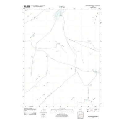
2011 Map of Buckhorn Reservoir
USGS Topo · Published 2011About this map
Buckhorn Reservoir and the Buckhorn Dam anchor the northern landscape of this Emery County region, where water management is central to the high desert terrain. The map traces a network of catchments and stock ponds including J J Reservoir, Lynns Pond, and Jim Wilson Reservoir, reflecting the area's pastoral and ranching dependencies. Topographically, the area is defined by massive formations like The Wedge and the Chalk Hills, with the Wedge Overlook providing a vantage over the deep incisions of Fuller Bottom Draw. Transport across this landscape relies on significant arterial routes like the Green River Cutoff Rd and Buckhorn Draw Rd, which navigate between the Black Hills and Little Cedar Mountain. This 2011 survey documents the persistent reliance on both natural seeps like Red Seep and engineered solutions like the Drought Relief Reservoir to sustain activity in the San Rafael Swell vicinity.
Find a feature on this map
42 named features on this map. Tap any name to fly to it.
Don’t see what you’re looking for? This feature index may not catch every label — zoom into the map to look around manually.
Map Details
Editions of this 2011 Buckhorn Reservoir Map
This is the sole edition of this map. No revisions or reprints were ever made.
Other maps of this area

1886 · Price River
USGS Topo · 1:250,000

1896 · Price River
USGS Topo · 1:250,000

1953 · Wilsonville SE
USGS Topo · 1:24,000

1953 · Red Plateau SW
USGS Topo · 1:24,000
1954 · Wilsonville SE
USGS Topo · 1:24,000

1956 · Price
USGS Topo · 1:250,000

1960 · Price
USGS Topo · 1:250,000

1962 · Price
USGS Topo · 1:250,000
1969 · Bob Hill Knoll
USGS Topo · 1:24,000
1969 · Buckhorn Reservoir
USGS Topo · 1:24,000