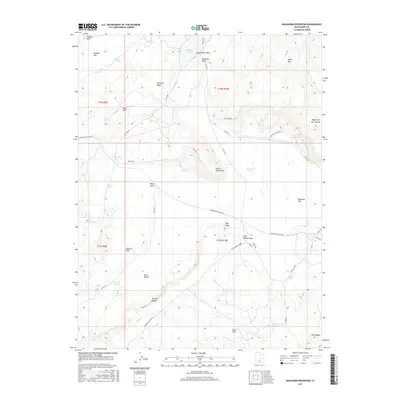
2017 Map of Buckhorn Reservoir
USGS Topo · Published 2017About this map
Buckhorn Reservoir and the surrounding high desert terrain define this portion of Emery County, where water management and ranching infrastructure dictate the landscape. The map reveals a complex network of small, scattered ponds and reservoirs, including Jim Wilson Reservoir, Lynns Pond, and Jorgensen Pond, which are vital for livestock in this arid environment. Transportation through the area centers on the historic Green River Cutoff Rd, which navigates between striking geological formations like The Red Ledges and the Chalk Hills. Notable landmarks such as Little Cedar Mtn and Hadden Reef provide vertical relief against the expansive stretches of Buckhorn Flat and Hadden Flat. The presence of features like Wedge Pond (Number 1) near The Wedge suggests a landscape managed for both seasonal runoff and long-term grazing utility.
Find a feature on this map
50 named features on this map. Tap any name to fly to it.
Don’t see what you’re looking for? This feature index may not catch every label — zoom into the map to look around manually.
Map Details
Editions of this 2017 Buckhorn Reservoir Map
This is the sole edition of this map. No revisions or reprints were ever made.
Other maps of this area

1886 · Price River
USGS Topo · 1:250,000

1896 · Price River
USGS Topo · 1:250,000

1953 · Wilsonville SE
USGS Topo · 1:24,000

1953 · Red Plateau SW
USGS Topo · 1:24,000
1954 · Wilsonville SE
USGS Topo · 1:24,000

1956 · Price
USGS Topo · 1:250,000

1960 · Price
USGS Topo · 1:250,000

1962 · Price
USGS Topo · 1:250,000
1969 · Bob Hill Knoll
USGS Topo · 1:24,000
1969 · Buckhorn Reservoir
USGS Topo · 1:24,000