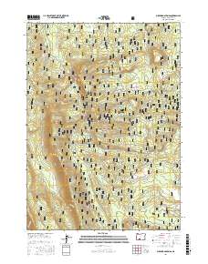
2017 Map of Buckhorn Springs
USGS Topo · Published 2017About this map
Winema National Forest dominates this section of Klamath County, where the high-elevation landscape is defined by its seasonal water sources and drainage patterns. The topography is marked by significant features such as Telephone Draw and Haystack Draw, which illustrate the complex watershed of the southern Oregon timberlands. Water distribution is centralized around Corral Spring, with several small creeks like Clover Cr and Meadow Cr weaving through the forested terrain. The map details a network of Forest Service infrastructure, specifically the numerous National Forest Development Roads like Nat For Dev Rd 4947 and Nat For Dev Rd 4584, which reveal the managed nature of this wilderness for timber and resource access. Historic transportation is further represented by the established Kirk Rd and Meadow Creek Rd, providing a clear look at how this remote area is navigated for recreation and forestry.
Find a feature on this map
17 named features on this map. Tap any name to fly to it.
Don’t see what you’re looking for? This feature index may not catch every label — zoom into the map to look around manually.
Map Details
Editions of this 2017 Buckhorn Springs Map
This is the sole edition of this map. No revisions or reprints were ever made.
Other maps of this area

1889 · Klamath
USGS Topo · 1:250,000

1894 · Klamath
USGS Topo · 1:250,000

1955 · Klamath Falls
USGS Topo · 1:250,000

1956 · Calimus Butte
USGS Topo · 1:62,500

1957 · Klamath Marsh
USGS Topo · 1:62,500

1958 · Klamath Falls
USGS Topo · 1:250,000

1960 · Fuego Mountain
USGS Topo · 1:62,500

1960 · Yamsay Mountain
USGS Topo · 1:62,500

1980 · Williamson River
USGS Topo · 1:100,000
1988 · Applegate Butte
USGS Topo · 1:24,000