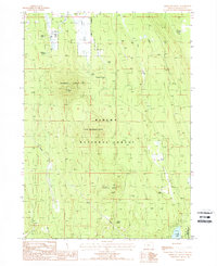
1988 Map of Applegate Butte
USGS Topo · Published 1988About this map
Winema National Forest dominates this section of Klamath County, where the high-elevation terrain is defined by volcanic features like Applegate Butte and Crawford Butte. Evidence of past human enterprise is visible at the Ray Ranch Ruins and a persistent Old Railroad Grade that cuts through the eastern half of the quadrangle. This industrial and ranching history is set against a landscape heavily marked by water resources, including Hawks Lake and the various tributaries of Wilson Creek and Hog Creek. The presence of several named water sources such as Slabhouse Springs and Beaverdam Springs suggests the historical importance of water for both local livestock and the timber industry. A Lookout stationed atop the primary peak provides a focal point for forest management, while a Pipeline and scattered Sand Pits further illustrate the mid-century utility of this wooded region.
Find a feature on this map
22 named features on this map. Tap any name to fly to it.
Don’t see what you’re looking for? This feature index may not catch every label — zoom into the map to look around manually.
Map Details
Editions of this 1988 Applegate Butte Map
This is the sole edition of this map. No revisions or reprints were ever made.
Other maps of this area

1889 · Klamath
USGS Topo · 1:250,000

1894 · Klamath
USGS Topo · 1:250,000

1955 · Klamath Falls
USGS Topo · 1:250,000

1956 · Calimus Butte
USGS Topo · 1:62,500

1957 · Chiloquin
USGS Topo · 1:62,500

1957 · Klamath Marsh
USGS Topo · 1:62,500

1957 · Lenz
USGS Topo · 1:62,500

1958 · Klamath Falls
USGS Topo · 1:250,000

1980 · Williamson River
USGS Topo · 1:100,000
1988 · Chiloquin
USGS Topo · 1:24,000