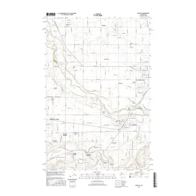
2017 Map of Buckley
USGS Topo · Published 2017About this map
Muckleshoot Prairie and the surrounding plateau between the White River and S Prairie Cr define this landscape along the border of King and Pierce counties. The map illustrates a dense network of agricultural and residential development centered around Enumclaw and Buckley, connected by the Enumclaw Buckley Rd and its namesake White River Bridge. Significant aviation infrastructure is present, ranging from the Enumclaw Airport to smaller private strips like Bryan Airport and the Flying H Ranch Airport. To the south, the terrain descends toward South Prairie Creek, where the historic junction at Cascade Junction and the community of Burnett mark the transition into the foothills. Several cemeteries, including the Krain Cem and Holy Cross Cem, provide specific points of interest for genealogists tracing the early families of the Wabash and Osceola areas.
Find a feature on this map
101 named features on this map. Tap any name to fly to it.
Don’t see what you’re looking for? This feature index may not catch every label — zoom into the map to look around manually.
Map Details
Editions of this 2017 Buckley Map
This is the sole edition of this map. No revisions or reprints were ever made.
Other maps of this area

1897 · Tacoma
USGS Topo · 1:125,000

1900 · Tacoma
USGS Topo · 1:125,000

1913 · Cedar Lake
USGS Topo · 1:125,000

1942 · Lake Tapps
USGS Topo · 1:62,500

1944 · Lake Tapps
USGS Topo · 1:62,500

1949 · Black Diamond
USGS Topo · 1:24,000

1949 · Auburn
USGS Topo · 1:24,000

1953 · Cumberland
USGS Topo · 1:24,000

1956 · Orting
USGS Topo · 1:24,000
1956 · Sumner
USGS Topo · 1:24,000