
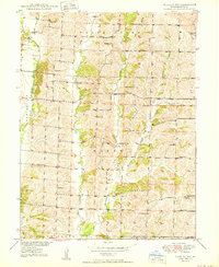
1950 Map of Bucklin NW
USGS Topo · Published 1950About this map
The agrarian landscape of Linn County is defined by a dense network of local schools and rural churches, reflecting the distributed settlement pattern of mid-century Missouri. The small community of Johnstown serves as a local landmark, situated among a series of named creek valleys including West Yellow Creek, Winnegan Creek, and Hamilton Branch. The map illustrates a rural society organized around crossroads institutions, with several legacy educational sites such as Hackler Sch, Clapp Sch, Harper Sch, and White Sch dotting the countryside.
Find a feature on this map
32 named features on this map. Tap any name to fly to it.
Don’t see what you’re looking for? This feature index may not catch every label — zoom into the map to look around manually.
Map Details
Editions of this 1950 Bucklin NW Map
2 editions found
Other maps of this area

1946 · Brookfield
USGS Topo · 1:62,500

1948 · Brookfield
USGS Topo · 1:62,500

1949 · Bucklin
USGS Topo · 1:24,000

1949 · Bucklin NW
USGS Topo · 1:24,000

1950 · Bucklin
USGS Topo · 1:24,000

1950 · New Cambria West
USGS Topo · 1:24,000

1951 · New Boston
USGS Topo · 1:24,000

1953 · Moberly
USGS Topo · 1:250,000

1954 · Centerville
USGS Topo · 1:250,000

1954 · Moberly
USGS Topo · 1:250,000