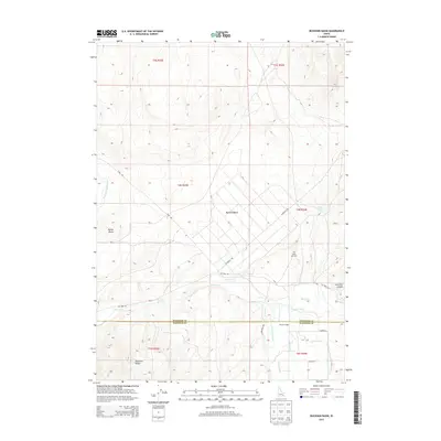
2013 Map of Buckskin Basin
USGS Topo · Published 2013About this map
Buckskin Basin serves as the focal point of this high-desert landscape in 2013, where the complex water management of the region is clearly etched into the terrain. The presence of the Fort Hall Main Canal and various irrigation works like the IR Ditch, Ballard Ditch, and Metz Ditch reveal the intensive modification of the Ross Fork drainage system to support agricultural use. The terrain is defined by the eastern edges of the Pocatello Range, rising to prominent landmarks such as Hyram Butte. Along the boundary between Bingham and Bannock counties, small-scale developments and local markers like Putnam Lodge and Ross Fork Cemetery provide points of reference within a network of rural routes including Gay Mine Road and Cosgrove Road. This survey documents a working landscape where industrial mining access and traditional ranching intersect through a sophisticated network of canals and laterals.
Find a feature on this map
31 named features on this map. Tap any name to fly to it.
Don’t see what you’re looking for? This feature index may not catch every label — zoom into the map to look around manually.
Map Details
Editions of this 2013 Buckskin Basin Map
This is the sole edition of this map. No revisions or reprints were ever made.
Other maps of this area

1937 · Pocatello
USGS Topo · 1:48,000

1940 · Blackfoot
USGS Topo · 1:62,500

1943 · Blackfoot
USGS Topo · 1:62,500

1944 · Pocatello
USGS Topo · 1:62,500

1954 · Pocatello
USGS Topo · 1:250,000

1955 · Lincoln Creek
USGS Topo · 1:24,000

1955 · Yandell Springs
USGS Topo · 1:62,500

1955 · Idaho Falls
USGS Topo · 1:250,000

1958 · Idaho Falls
USGS Topo · 1:250,000

1958 · Pocatello
USGS Topo · 1:250,000