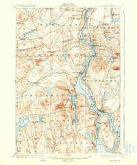
1902 Map of Bucksport
USGS Topo · Published 1936About this map
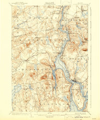
Penobscot River commerce and industrial navigation define this landscape at the dawn of the twentieth century, shown here as a complex network of maritime and rail connections. The map details a bustling corridor where the Steamboat Route follows the river's deep channel past Bald Hill Cove and North Winterport, while the Maine Central RR Bucksport Br terminates at the riverbank near Bucksport. This era was one of intense resource extraction and military presence, evidenced by the large Quarry on the slopes of Mt Waldo and the tactical positioning of Fort Knox overlooking the Prospect Ferry crossing. Settlement patterns follow the rugged topography, with numerous family-named landmarks like Nealeys Corner and Ellingwoods Corner dotting the interior highlands. Further south, the island community of Verona and the shoreline at Sandy Point mark the transition toward the larger bay.
Find a feature on this map
93 named features on this map. Tap any name to fly to it.
Don’t see what you’re looking for? This feature index may not catch every label — zoom into the map to look around manually.
Map Details
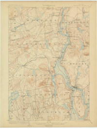
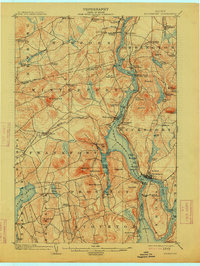
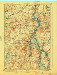
Editions of this 1902 Bucksport Map
6 editions found
Other maps of this area

1900 · Orland
USGS Topo · 1:62,500

1900 · Bucksport
USGS Topo · 1:62,500

1902 · Orono
USGS Topo · 1:62,500

1902 · Bucksport
USGS Topo · 1:62,500

1902 · Bangor
USGS Topo · 1:62,500

1902 · Castine
USGS Topo · 1:62,500

1904 · Castine
USGS Topo · 1:62,500

1904 · Bluehill
USGS Topo · 1:62,500

1905 · Penobscot Bay
USGS Topo · 1:125,000

1915 · Belfast
USGS Topo · 1:62,500