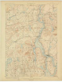
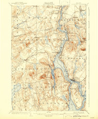
1902 Map of Bucksport
USGS Topo · Published 1906About this map
The Penobscot River serves as the dominant artery of this coastal Maine landscape, dividing the communities of Bucksport and Winterport at the turn of the twentieth century. This survey documents a transitional era in transportation, showing the Maine Central Railroad and the Electric Route running parallel to the water, while the Prospect Ferry still provides a vital crossing point near the massive stone works of Fort Knox.
Find a feature on this map
96 named features on this map. Tap any name to fly to it.
Don’t see what you’re looking for? This feature index may not catch every label — zoom into the map to look around manually.
Map Details
Editions of this 1902 Bucksport Map
6 editions found
Other maps of this area

1900 · Orland
USGS Topo · 1:62,500

1900 · Bucksport
USGS Topo · 1:62,500

1902 · Orono
USGS Topo · 1:62,500

1902 · Bucksport
USGS Topo · 1:62,500

1902 · Bangor
USGS Topo · 1:62,500

1902 · Castine
USGS Topo · 1:62,500

1904 · Castine
USGS Topo · 1:62,500

1904 · Bluehill
USGS Topo · 1:62,500

1905 · Penobscot Bay
USGS Topo · 1:125,000

1915 · Belfast
USGS Topo · 1:62,500