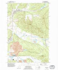
1990 Map of Bucoda
USGS Topo · Published 1995About this map
Tenino and Bucoda anchor this Washington landscape during the 1990s, a region defined by its complex industrial and natural geography. The map reveals a transition from valley floors to high elevations like Northcraft Mountain and Crawford Mountain, where a Lookout Tower still stands. Significant industrial history is evident in the southern reaches, particularly within the Hanaford Valley where the Black Prince Mine and other extractive sites operate near the Thurston and Lewis County line. The settlement of Tono sits nestled among these mining operations, connected by an Old Railroad Grade that traces the historic path of coal transport. Local landmarks such as the Memorial Swimming Pool in Tenino and the Forest Cemetery on Frost Prairie offer valuable touchpoints for genealogists and local historians studying the civic and social development of these communities along the Skookumchuck River.
Find a feature on this map
35 named features on this map. Tap any name to fly to it.
Don’t see what you’re looking for? This feature index may not catch every label — zoom into the map to look around manually.
Map Details
Editions of this 1990 Bucoda Map
This is the sole edition of this map. No revisions or reprints were ever made.
Other maps of this area

1916 · Chehalis
USGS Topo · 1:125,000

1940 · Tenino
USGS Topo · 1:62,500

1943 · Willapa
USGS Topo · 1:62,500

1944 · Tenino
USGS Topo · 1:62,500

1944 · Yelm
USGS Topo · 1:62,500

1949 · Yelm
USGS Topo · 1:62,500

1949 · Tenino
USGS Topo · 1:62,500

1953 · Hoquiam
USGS Topo · 1:250,000

1954 · Onalaska
USGS Topo · 1:62,500

1954 · Centralia
USGS Topo · 1:62,500