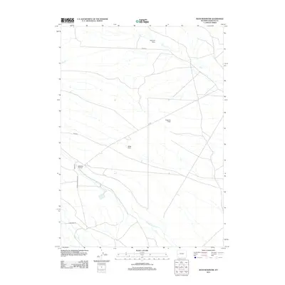
2012 Map of Budd Reservoir
USGS Topo · Published 2012About this map
Muddy Cr and Meadow Canyon Cr define the drainage patterns of this high-plains landscape in Sublette County, Wyoming. The terrain is marked by a series of significant depressions and canyons, including Antelope Draw, Ryegrass Draw, and Billies Draw. These features suggest a region shaped by seasonal water runoff and an arid environment where topography dictates movement. Transportation across this expanse relies on Bureau of Land Management routes like BLM 5212 and BLM 5204, alongside locally named thoroughfares such as Birds Rd and Guio Budd Rd. The presence of Meadow Canyon in the southwestern quadrant provides a distinct contrast to the more open draws found to the north and east, illustrating the complex erosional history of the Wyoming interior.
Find a feature on this map
11 named features on this map. Tap any name to fly to it.
Don’t see what you’re looking for? This feature index may not catch every label — zoom into the map to look around manually.
Map Details
Editions of this 2012 Budd Reservoir Map
This is the sole edition of this map. No revisions or reprints were ever made.
Other maps of this area

1939 · Big Piney
USGS Topo · 1:125,000

1942 · Big Piney
USGS Topo · 1:125,000

1955 · Preston
USGS Topo · 1:250,000

1958 · Preston
USGS Topo · 1:250,000

1962 · Preston
USGS Topo · 1:250,000
1970 · Budd Reservoir
USGS Topo · 1:24,000
1970 · Big Piney West
USGS Topo · 1:24,000
1970 · Daniel
USGS Topo · 1:24,000
1970 · Ball Island
USGS Topo · 1:24,000
1970 · Onion Springs
USGS Topo · 1:24,000