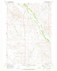
1970 Map of Ball Island
USGS Topo · Published 1973About this map
Ball Island sits at the heart of an intricate irrigation network in Sublette County, defined by the winding course of Cottonwood Creek and the Green River. In the early 1970s, the landscape was a complex system of water management, where dozens of named channels like Essex Ditch, Ranchero Canal, and Jigger Ditch diverted mountain runoff to the arid flats. This infrastructure supported ranching life near the Soap Hole Basin and the striking Red Hills formation. Evidence of early settlement and land use is visible at the Ball Cem and along Luman Road, while the southern reaches show early water storage at Billy Canyon Reservoir No 1. The map reveals a high-altitude landscape where natural drainage and human engineering intersect to sustain the high plains.
Find a feature on this map
28 named features on this map. Tap any name to fly to it.
Don’t see what you’re looking for? This feature index may not catch every label — zoom into the map to look around manually.
Map Details
Editions of this 1970 Ball Island Map
This is the sole edition of this map. No revisions or reprints were ever made.
Other maps of this area

1939 · Big Piney
USGS Topo · 1:125,000

1942 · Big Piney
USGS Topo · 1:125,000

1955 · Preston
USGS Topo · 1:250,000

1955 · Lander
USGS Topo · 1:250,000

1958 · Lander
USGS Topo · 1:250,000

1958 · Preston
USGS Topo · 1:250,000

1961 · Lander
USGS Topo · 1:250,000

1962 · Preston
USGS Topo · 1:250,000

1964 · Ross Butte
USGS Topo · 1:24,000

1964 · Mount Airy
USGS Topo · 1:24,000