
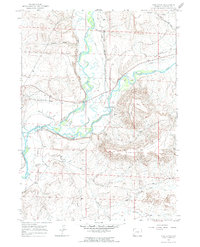
1964 Map of Ross Butte
USGS Topo · Published 1968About this map
The Green River and New Fork River converge in this high-desert landscape of Sublette County, marking a vital hydrological junction where braided river channels cut through arid plateaus. The historical path of the Emigrant Trail traverses the northwest corner, following the same natural corridors used by early westward travelers across the Wyoming basins. This 1960s survey illustrates a specialized ranching economy dependent on an intricate system of water management, visible through numerous named irrigation features like the Hanna Ditch, Sheep Ditch, and Wardell Ditch. Elevated terrain such as Ross Butte and Ross Ridge dominate the eastern half of the map, providing a stark contrast to the riparian lowlands of Alkali Creek and Granite Wash. Infrastructure of the mid-century is represented by The Mesa Road and a solitary Gaging Sta along the riverbank.
Find a feature on this map
21 named features on this map. Tap any name to fly to it.
Don’t see what you’re looking for? This feature index may not catch every label — zoom into the map to look around manually.
Map Details
Editions of this 1964 Ross Butte Map
2 editions found
Other maps of this area

1939 · Big Piney
USGS Topo · 1:125,000

1942 · Big Piney
USGS Topo · 1:125,000

1955 · Preston
USGS Topo · 1:250,000

1955 · Lander
USGS Topo · 1:250,000

1958 · Lander
USGS Topo · 1:250,000

1958 · Preston
USGS Topo · 1:250,000

1961 · Lander
USGS Topo · 1:250,000

1962 · Preston
USGS Topo · 1:250,000

1964 · Two Buttes Reservoir
USGS Topo · 1:24,000
1964 · Olsen Ranch
USGS Topo · 1:24,000