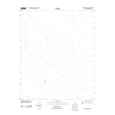
2012 Map of Budweiser Wash
USGS Topo · Published 2012About this map
Budweiser Wash defines the drainage patterns of this arid corner of San Bernardino County, where seasonal watercourses trace intricate paths across the desert floor. This 2012 survey illustrates the stark geomorphology of the region, anchored by the southern reaches of the Old Dad Mountains. The landscape is dominated by these dry washes, including Orange Blossom Wash in the southeast, which serve as the primary topographical markers in a terrain largely devoid of permanent settlements or infrastructure. For those studying the Mojave Desert's hydrological networks, the map reveals how these ephemeral streams converge and diverge as they navigate the slopes and alluvial fans of the surrounding highlands.
Find a feature on this map
3 named features on this map. Tap any name to fly to it.
Don’t see what you’re looking for? This feature index may not catch every label — zoom into the map to look around manually.
Map Details
Editions of this 2012 Budweiser Wash Map
This is the sole edition of this map. No revisions or reprints were ever made.
Other maps of this area

1942 · Amboy
USGS Topo · 1:250,000

1943 · Amboy
USGS Topo · 1:250,000

1954 · Needles
USGS Topo · 1:250,000

1956 · Needles
USGS Topo · 1:250,000

1956 · Cadiz
USGS Topo · 1:62,500
1956 · Bagdad
USGS Topo · 1:62,500

1956 · Flynn
USGS Topo · 1:62,500
1957 · Kerens
USGS Topo · 1:62,500
1960 · Bagdad
USGS Topo · 1:50,000

1981 · Needles
USGS Topo · 1:250,000