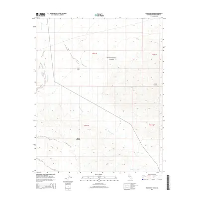
2015 Map of Budweiser Wash
USGS Topo · Published 2015About this map
The Mojave National Preserve encompasses most of this 2015 topographic record, revealing a landscape defined by dramatic elevation changes and ephemeral watercourses. In the eastern portion of the sheet, the Granite Mountains rise sharply, creating a complex series of contours that contrast with the broader desert floor. To the southwest, the Old Dad Mountains further delineate the terrain of the Mojave Desert. The map meticulously tracks the drainage patterns characteristic of the high desert, most notably Budweiser Wash, which cuts across the central and western sections of the quadrangle. In the south, the Orange Blossom Wash provides additional evidence of how seasonal water flow has historically shaped this arid environment. This survey captures a remote section of San Bernardino County where land use is dictated by the harsh desert climate and the protective boundaries of the national preserve.
Find a feature on this map
10 named features on this map. Tap any name to fly to it.
Don’t see what you’re looking for? This feature index may not catch every label — zoom into the map to look around manually.
Map Details
Editions of this 2015 Budweiser Wash Map
This is the sole edition of this map. No revisions or reprints were ever made.
Other maps of this area

1942 · Amboy
USGS Topo · 1:250,000

1943 · Amboy
USGS Topo · 1:250,000

1954 · Needles
USGS Topo · 1:250,000

1956 · Needles
USGS Topo · 1:250,000

1956 · Cadiz
USGS Topo · 1:62,500
1956 · Bagdad
USGS Topo · 1:62,500

1956 · Flynn
USGS Topo · 1:62,500
1957 · Kerens
USGS Topo · 1:62,500
1960 · Bagdad
USGS Topo · 1:50,000

1981 · Needles
USGS Topo · 1:250,000