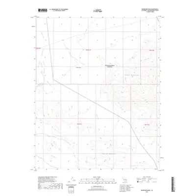
2018 Map of Budweiser Wash
USGS Topo · Published 2018About this map
The Mojave National Preserve encompasses the majority of this desert landscape, where the shifting sands of the Mojave Desert meet the rising elevations of the Granite Mountains and Old Dad Mountains. This arid region in San Bernardino County is defined by its complex drainage network, primarily the namesake Budweiser Wash which trends south through the center of the sheet, and the Orange Blossom Wash in the southeastern corner. Mapping of the area reveals the stark topographical contrast between the broad alluvial plains and the high, localized peaks. The inclusion of Bull Canyon in the northeast highlights the dramatic erosion patterns common to this part of the California desert. This 2018 survey serves as a modern record of natural landforms within a federally protected wilderness, illustrating the relationship between seasonal water flow and the permanent mountain structures.
Find a feature on this map
12 named features on this map. Tap any name to fly to it.
Don’t see what you’re looking for? This feature index may not catch every label — zoom into the map to look around manually.
Map Details
Editions of this 2018 Budweiser Wash Map
This is the sole edition of this map. No revisions or reprints were ever made.
Other maps of this area

1942 · Amboy
USGS Topo · 1:250,000

1943 · Amboy
USGS Topo · 1:250,000

1954 · Needles
USGS Topo · 1:250,000

1956 · Needles
USGS Topo · 1:250,000

1956 · Cadiz
USGS Topo · 1:62,500
1956 · Bagdad
USGS Topo · 1:62,500

1956 · Flynn
USGS Topo · 1:62,500
1957 · Kerens
USGS Topo · 1:62,500
1960 · Bagdad
USGS Topo · 1:50,000

1981 · Needles
USGS Topo · 1:250,000