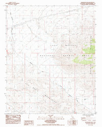
1984 Map of Budweiser Wash
USGS Topo · Published 1985About this map
East Mojave National Scenic Area dominates the high desert landscape in this mid-1980s provisional study, showing the convergence of several major topographic features. The Old Dad Mountains rise sharply in the southwest, while the western edges of the Granite Mountains are visible to the east. The drainage of Budweiser Wash winds through the terrain, serving as a primary natural landmark for the region. Modern infrastructure is represented by a long Steel Tower Transmission Line and a parallel Pipeline crossing the northern sections. This map provides a look at the desert's management before its 1994 transition to a National Preserve, including specific water management sites like the Guzzler noted near the eastern wash. The map's status as a provisional edition reflects the use of 1980 aerial photography to document this sparsely settled portion of San Bernardino County.
Find a feature on this map
8 named features on this map. Tap any name to fly to it.
Don’t see what you’re looking for? This feature index may not catch every label — zoom into the map to look around manually.
Map Details
Editions of this 1984 Budweiser Wash Map
This is the sole edition of this map. No revisions or reprints were ever made.
Other maps of this area

1942 · Amboy
USGS Topo · 1:250,000

1943 · Amboy
USGS Topo · 1:250,000

1954 · Needles
USGS Topo · 1:250,000

1956 · Needles
USGS Topo · 1:250,000

1956 · Cadiz
USGS Topo · 1:62,500
1956 · Bagdad
USGS Topo · 1:62,500

1956 · Flynn
USGS Topo · 1:62,500
1957 · Kerens
USGS Topo · 1:62,500
1960 · Bagdad
USGS Topo · 1:50,000

1981 · Needles
USGS Topo · 1:250,000