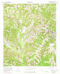
1955 Map of Buena Vista
USGS Topo · Published 1975About this map
Buena Vista serves as the focal point of this mid-century survey of Marion County, Georgia, showing the town's position at the intersection of local routes and the Central of Georgia railroad. The surrounding landscape is characterized by a dense network of creeks, including the southward-flowing Kinchafoonee Creek and Lanahassee Creek, which carve through the terrain. Agricultural and social hubs are clearly marked by numerous rural sanctuaries such as Poplar Springs Ch, Browns Chapel, and Haile Chapel, reflecting a deeply rooted community structure.
Find a feature on this map
29 named features on this map. Tap any name to fly to it.
Don’t see what you’re looking for? This feature index may not catch every label — zoom into the map to look around manually.
Map Details
Editions of this 1955 Buena Vista Map
2 editions found
Other maps of this area

1949 · Glen Alta
USGS Topo · 1:24,000

1949 · Buena Vista NW
USGS Topo · 1:24,000

1950 · Buena Vista NE
USGS Topo · 1:24,000

1950 · Buena Vista
USGS Topo · 1:24,000

1950 · Buena Vista
USGS Topo · 1:62,500
1955 · Buena Vista NW
USGS Topo · 1:24,000

1955 · Buena Vista
USGS Topo · 1:24,000

1955 · Buena Vista NE
USGS Topo · 1:24,000
1955 · Glen Alta
USGS Topo · 1:24,000
1955 · Buena Vista
USGS Topo · 1:62,500