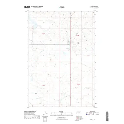
2017 Map of Buffalo
USGS Topo · Published 2017About this map
Buffalo serves as a remote hub in the high plains of Harding County, organized around a grid of streets including 3rd Ave N, E Allison St, and Connel St. The settlement sits just north of the S Fork Grand River, which meanders through a landscape defined by expansive ranching townships and intermittent watercourses. Local infrastructure is concentrated around the town center, featuring the Harding County Airport to the east and the Buffalo Cem to the south. The surrounding terrain is drained by numerous small tributaries such as Rush Cr, Slick Cr, and Buffalo Cr, while Lake Gardner provides a distinct hydrographic feature in the northwestern section. This layout reflects the enduring spatial organization of a rural South Dakota county seat, where connectivity relies on long-distance routes like Old Hwy 85 and Clanton Rd.
Find a feature on this map
23 named features on this map. Tap any name to fly to it.
Don’t see what you’re looking for? This feature index may not catch every label — zoom into the map to look around manually.
Map Details
Editions of this 2017 Buffalo Map
This is the sole edition of this map. No revisions or reprints were ever made.
Other maps of this area

1935 · Reva
USGS Topo · 1:125,000

1935 · Hoover
USGS Topo · 1:125,000

1935 · Harding
USGS Topo · 1:125,000

1935 · Buffalo
USGS Topo · 1:125,000

1954 · Lemmon
USGS Topo · 1:250,000

1957 · Lemmon
USGS Topo · 1:250,000

1971 · Buffalo
USGS Topo · 1:24,000
1971 · Lahti Butte
USGS Topo · 1:24,000

1971 · McKenzie Butte
USGS Topo · 1:24,000
1971 · Sheep Pen Draw SW
USGS Topo · 1:24,000