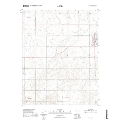
2018 Map of Buffalo
USGS Topo · Published 2018About this map
Buffalo serves as the focal point of this Harper County landscape, organized by a precise grid of residential streets like NW 1st St and NE 2nd St. The town is surrounded by a sprawling network of section-line roads, including E0100 Rd and N1900 Rd, which reflect the region's agricultural heritage and systematic land division. The terrain is defined by the drainage of Buffalo Cr and Rodkeys Cr, which wind through the plains toward several numbered water storage features such as 059064 Reservoir and 059062 Reservoir. South of the town center, Gyp Valley Cem stands as a significant landmark for genealogical research, situated near the intersection of E0180 Rd and N1875 Rd. The landscape demonstrates a reliance on managed water resources in this prairie environment.
Find a feature on this map
53 named features on this map. Tap any name to fly to it.
Don’t see what you’re looking for? This feature index may not catch every label — zoom into the map to look around manually.
Map Details
Editions of this 2018 Buffalo Map
This is the sole edition of this map. No revisions or reprints were ever made.
Other maps of this area

1955 · Woodward
USGS Topo · 1:250,000

1958 · Woodward
USGS Topo · 1:250,000

1970 · Buffalo SE
USGS Topo · 1:24,000

1970 · Buffalo NW
USGS Topo · 1:24,000

1970 · Rosston NE
USGS Topo · 1:24,000

1970 · Buffalo NE
USGS Topo · 1:24,000

1970 · Buffalo
USGS Topo · 1:24,000

1971 · Rosston SE
USGS Topo · 1:24,000

1971 · Fort Supply NW
USGS Topo · 1:24,000

1971 · Fort Supply NE
USGS Topo · 1:24,000