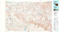
1985 Map of Buffalo
USGS Topo · Published 1989About this map
The high plains of Northwest Oklahoma meet the Kansas border in this mid-1980s survey, defined by the winding paths of the Cimarron River and Beaver River. The regional landscape is marked by the presence of the Western State Hospital and the subterranean features of Alabaster Caverns State Park. Large-scale Oil and Gas Field operations are prominent throughout the territory, illustrating the mineral-rich economy of the era. Settlement patterns follow the Atchison Topeka and Santa Fe railroad line, which connects rural outposts such as Buffalo, Selman, and Freedom. In the southern reaches, the Fort Supply Lake reservoir provides a major hydrological landmark, while smaller communities like Laverne and May anchor the agricultural and ranching districts. This map captures the transition from river-bottom ranchlands to the open prairie, showing the interplay between transportation networks and natural resources.
Find a feature on this map
36 named features on this map. Tap any name to fly to it.
Don’t see what you’re looking for? This feature index may not catch every label — zoom into the map to look around manually.
Map Details
Editions of this 1985 Buffalo Map
2 editions found
Other maps of this area

1891 · Medicine Lodge
USGS Topo · 1:125,000

1892 · Meade
USGS Topo · 1:125,000

1892 · Coldwater
USGS Topo · 1:125,000

1893 · Medicine Lodge
USGS Topo · 1:125,000

1894 · Sitka
USGS Topo · 1:62,500

1896 · Ashland
USGS Topo · 1:125,000

1954 · Perryton
USGS Topo · 1:250,000

1955 · Woodward
USGS Topo · 1:250,000

1955 · Pratt
USGS Topo · 1:250,000

1955 · Dodge City
USGS Topo · 1:250,000